
The world's most sophisticated urban road pricing system is going to become even more sophisticated as Singapore looks like being the first city to ever implement a full distance, time, location and vehicle type based road pricing scheme, using GNSS technologies.

Singapore's Land Transport Authority announced the winning bid for its procurement of a GNSS based electronic road pricing (ERP) system on 25 February - a consortium of NCS and Mitsubishi Heavy Industries Engine System Asia. NCS holds the contract for maintaining the ERP system and Mitsubishi was responsible for developing the original ERP system. NCS is a subsidiary of Singtel, Singapore's major telecommunications carrier, itself owned by Temasek, the Singaporean Government investment company that invests in firms such as Singapore Airlines.
Singapore's Land Transport Authority announced the winning bid for its procurement of a GNSS based electronic road pricing (ERP) system on 25 February - a consortium of NCS and Mitsubishi Heavy Industries Engine System Asia. NCS holds the contract for maintaining the ERP system and Mitsubishi was responsible for developing the original ERP system. NCS is a subsidiary of Singtel, Singapore's major telecommunications carrier, itself owned by Temasek, the Singaporean Government investment company that invests in firms such as Singapore Airlines.
The cost is S$556m (US$407m) and implementation is expected in 2020, with development starting around April. According to Channel News Asia, the existing ERP system will operate in parallel for an 18 month transition period. Two other participating suppliers were ST Electronics, which bid the project for S$1.26b, and the consortium of Watchdata Technologies and Beijing Watchdata System which did not reach the bidding phase. This enormous difference in bidding price must have been influential, as well as NCS/Mitsubishi's long standing experience and understanding of the current ERP system.
The winning consortium will build and maintain the next generation GNSS urban road pricing system. Although it will primarily use GNSS systems to detect and measure distance, it is also reported that beacons may be used to supplement GNSS signals in some locations. It is using 4G systems for communication, but according to Business Times intends to still be compatible with stored value cards - a first for GNSS charging systems (as no OBUs in use anywhere currently take payment cards).
Channel News Asia published this image depicting some value added services that the new system will bring, including real-time traffic and parking information, and payment systems for parking. The OBU is intended to be "open to new applications" to enable the ERP system to be a telematics platform. One feature will be warning in advance of a charged road, so that a road user can choose to divert elsewhere.
 |
| Singapore congestion charging based on GPS |
Context
Since September 1998, Singapore has had the world's most sophisticated urban congestion charging scheme, which has directly targeted only segments of roads that are heavily congested and applies prices to those segments of road based on achieving a minimum "level of service" (operating speed). Its prices vary by time of day and direction of travel, apply to virtually all vehicles (including motorcycles and buses) and are reviewed regularly to ensure they are appropriate - that means the prices rise if speeds drop below a set threshold, or are reduced if they go above another threshold. The intention being to optimise the use of the network.
It goes back to the Area Licensing Scheme in 1975, which essentially introduced a pass based system of congestion charging for access into central Singapore, and the subsequent introduction of controls on the numbers of vehicles allowed to be licensed in the country (a policy that is more plausible in a city-state than in a larger country, let alone the individual liberties concerns in many countries).
Singapore has curbed car ownership by limiting the number of cars in the country, but it has not stopped the country building adequate road capacity. 12% of the land area is taken up by roads, although again, in a city-state it is hardly surprising, built up areas need access which means they need roads, and there is little room for farms or forests which can cover vast areas with little road access.
Transport Minister Khaw Boon Wan has a target of 75% of trips made by public transport by 2030 and 85% by 2050. It is doing this by increasing the bus fleet by 35%, doubling the rail network, expanding cycling paths and quadrupling covered walkway distance (essential during Singapore's tropical downpours). However, I wonder how much difference vehicle automation might make, as Singapore would appear to be well positioned to pilot incentivising automated vehicles to get better use out of the road network.
ERP today
An interactive map of all charging points which you can click to get the prices of reach vehicle class per time of day is here. Most gantries operate at peak times only, but some charge during interpeak periods and some on Saturdays (e.g. Orchard Road in downtown Singapore).
 |
| Singapore ERP gantry points |
 |
| Prices for cars at set times at one Singapore ERP charging point |
Prices range considerably, with prices set to reflect vehicle type according to metrics of road space occupancy based on PCU (passenger car unit equivalent) Cars, vans and taxis are 1 unit, motorcycles are half, heavy goods vehicles and minibuses are 1.5 and the largest trucks and full sized buses are 2. This is a measure of congestion impact and nothing else.
Rates are reviewed quarterly to ensure charges maintain average speeds of 20-30kph on main roads and 45-65kph on expressways. If speeds drop below that at specific times passing by a gantry on a regular basis, prices for that direction of travel at that location are increased (to reduce congestion). If they go above that, prices are reduced (as it is assumed prices are too high and are suppressing efficient demand). This excellent article (PDF) published five years after ERP was introduced discusses Singapore's experience with the system and the results. Violation rates are less than 0.5% of trips.
Singapore has long used what is now a rather dated tag and beacon system (DSRC) that is non-standard, and involves a two-way communication with vehicle on-board units (OBUs) by deducting prepaid credit from smart cards inserted into the OBUs. To achieve the detection, the communication from the unit and back to the smart card (and provide back-up ANPR cameras for enforcement) has resulted in Singapore having very large elaborate gantries that many cities would see as unsightly (and which are increasingly controversial in Singapore itself).
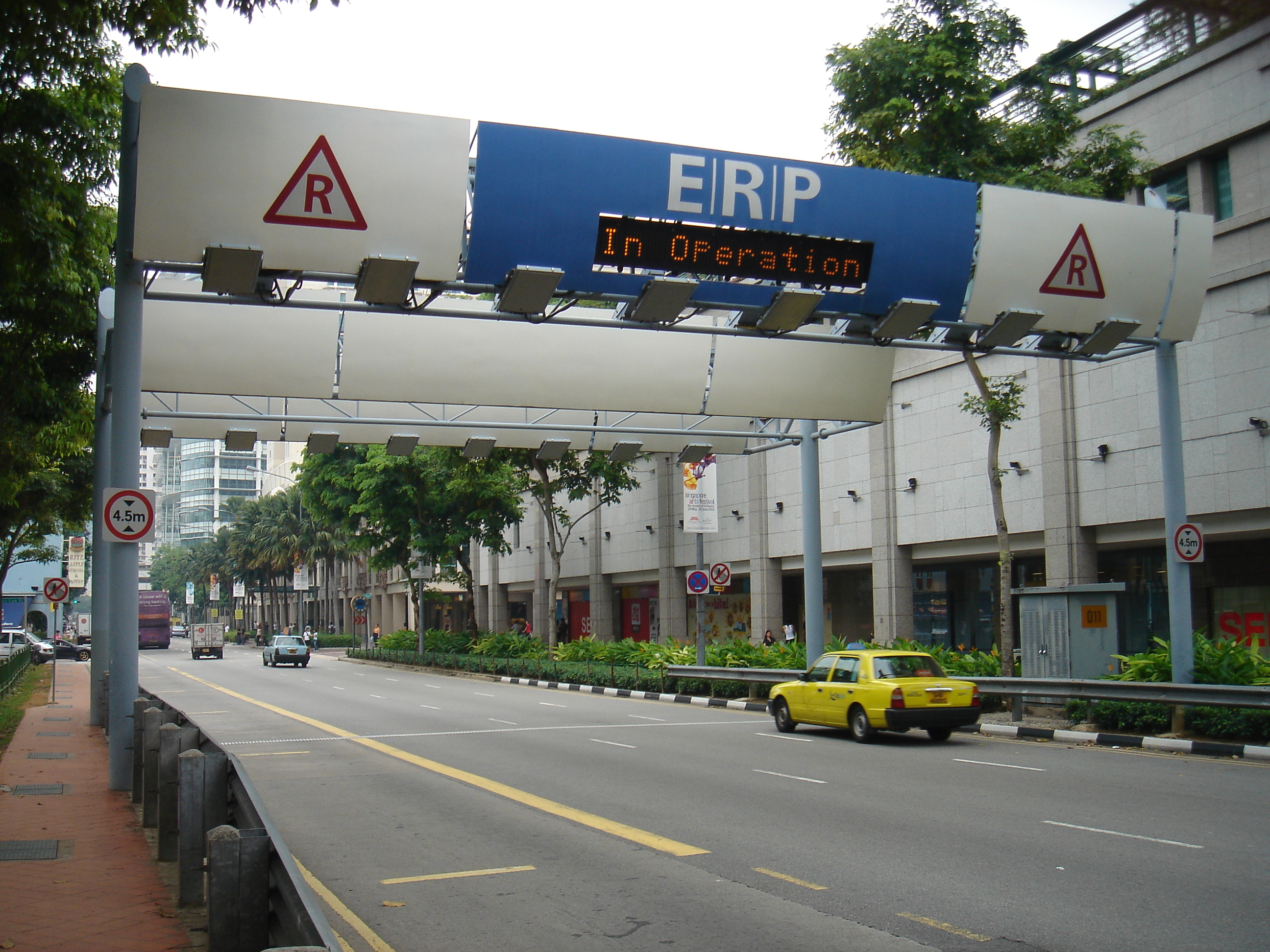 |
| Singapore ERP gantry |
Future policy
The shift to GNSS should enable these to be dismantled or at least scaled down, as I presume there will still be a need for some gantries for ANPR enforcement of the system, but these may be much less intrusive and more on the scale of the current generation of London congestion charging/low emission zone cameras as below:
 |
| Cameras used for London Low Emission Zone |
Channel News Asia says that Transport Minister Khaw Boon Wan claims the new system will be fairer:
“For example, motorists who travel a full stretch on the congested road can be charged more than those who travel a part of it,” he said
This illustration from the Land Transport Authority (LTA) depicts how the system is expected to work, although it is at such a high level, much detail is still to be worked out:
 |
| Singapore GPS congestion pricing system architecture |
However, it is not a national scheme, with Transport Minister Khaw Boon Wan confirming in the Straits Times that:
"While the next generation ERP system allows for islandwide coverage, the current policy is to price only congested roads."
The Minister did confirm that the policy did need to be finalised through to 2020.
The proposal has been criticised by Straits Times Editor at large Han Fook Kwang, who says for the S$556 million (US$404 million) spent on the system the government should have the policy right by now and that policy should be clear before buying a system. I believe this may be a partly unfair criticism. GNSS clearly enables Singapore to do what it is doing now, but with much flexibility to do more. Charging by distance is more nuanced than charging by point, as now. However, there are legitimate questions about rate setting which deserve discussion.
Eileen Yu in ZDNet points out that no statistics have been provided to explain how the new system will be fairer to motorists noting that the Ministry of Transport claims that money collected is less than that spent on the road network (which is understandable since it only charges a fraction of road use). Perhaps more importantly, nothing has been stated about protecting using privacy and security, although I would assume these should be core to the new system.
Eileen Yu in ZDNet points out that no statistics have been provided to explain how the new system will be fairer to motorists noting that the Ministry of Transport claims that money collected is less than that spent on the road network (which is understandable since it only charges a fraction of road use). Perhaps more importantly, nothing has been stated about protecting using privacy and security, although I would assume these should be core to the new system.
A purely congestion focused system should treat different vehicles according to road-space occupation (called PCU or passenger car unit equivalents), and then location and time of day much as Singapore does now - targeting levels of service on the network (raising and lowering prices to optimise network utilisation).
Professor Lee Der Hong from the Department of Civil and Environmental Engineering from the National University of Singapore says in this article on Channel News Asia that it will allow Singapore to move away from the Certificate of Entitlement approach to managing congestion (which requires all purchasers of a car to purchase a Certificate of Entitlement to own a vehicle, the number of which is capped by the Government) towards regulating usage by price. The point being that owning a car itself is not a public policy problem, but using it when and where road space is inadequate for unconstrained demand. Notable in that report, an unnamed person was concerned about the privacy implications of a system that some think will allow tracking of all vehicle movements by the state - an issue so frequently raised with time, distance, place road pricing.
Singapore can design a policy that manages congestion more effectively, better targets congestion and is both user friendly, minimises operating costs and generates more revenue. It could liberalise or replace the Certificate of Entitlement programme with both GNSS ERP and perhaps a requirement that anyone buying a vehicle own or have the rights to a parking space for the vehicle (which is another physical constraint - akin to road space - upon car use).
It will be interesting to see how policy develops and to see if others follow close behind. Singapore looks like remaining the world leader in urban road pricing. GNSS technologies promise the ability to introduce congestion pricing on roads with the maximum level of flexibility and economically efficient pricing, with minimal distortions on behaviour. Will Singapore take advantage of this flexibility and be the first country in the world to implement full distance, time of day, location and vehicle type road pricing, showing others the "holy grail" of road pricing?
I am interested in how Singapore will be handling the issue of GNSS positioning accuracy, particularly in urban canyons. See the end of: https://www.lta.gov.sg/ltaacademy/pdf/J15Nov_p18Menon_SingaporesRoadPricing.pdf
ReplyDeleteExcellent piece, thanks John I will post a link to that on the sidebar
ReplyDelete